
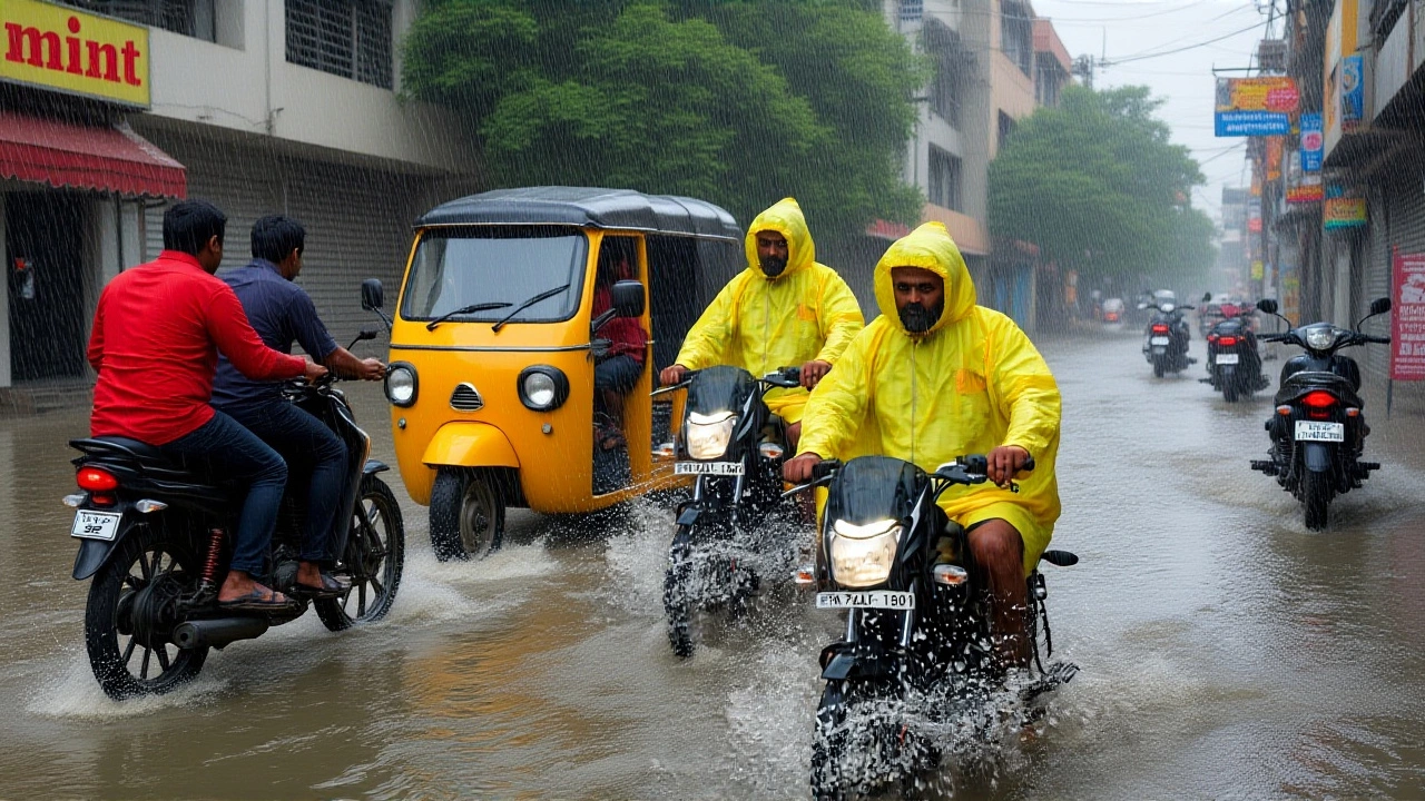
By 5:30 PM IST on October 29, 2025, Cyclone Montha — once a fierce storm slamming into Andhra Pradesh — had collapsed into a deep depression, its center hovering over southern Chhattisgarh. The transformation wasn’t peaceful. It left behind flooded fields, broken railway lines, and farmers nervously watching the sky. The Indian Meteorological Department (IMD) had warned for days, but the scale of the damage still caught many off guard. In just 48 hours, this system went from a 110 km/h gale-force cyclone to a slow-moving rain machine soaking five districts in red alert — and the worst might not be over.
Landfall to Depression: The Cyclone’s Path
Cyclone Montha made landfall near Kakinada, Andhra Pradesh, on the night of October 28, 2025, with sustained winds of 100 km/h. For nearly six hours, the storm tore through coastal towns, uprooting trees, collapsing tin roofs, and flooding low-lying streets. By dawn on October 29, it had crossed into Odisha at 74 km/h, dumping over 90 mm of rain in places like Khurda and Balasore. Then, it turned northwest — straight into the forested highlands of Chhattisgarh.
By midday on the 29th, the IMD confirmed the storm had weakened to a depression, but its moisture hadn’t dissipated. Instead, it was spreading like ink in water — soaking Narayanpur, Bastar, Bijapur, Dantewada, and Sama. Singhpur, too, was under watch. Rainfall totals hit 105 mm in Mayurbhanj (Odisha), 93.5 mm in Balasore, and 74.4 mm in Chandbali. In Raipur, the sky stayed gray from Thursday morning, with intermittent showers keeping humidity near 90%.
Infrastructure in the Crosshairs
The real toll emerged on the railways. Landslides ripped through the Kirandul-Kottavalasa line in the Tyada-Chimidipalli stretch, washing out a culvert and forcing the cancellation of two trains. Local officials said rescue teams were deployed, but dense fog and muddy trails slowed progress. In Jashpur, heavy rain began Wednesday morning and didn’t let up — roads turned to rivers, and villages reported isolated power outages.
Temperature swings were equally jarring. Wednesday’s high of 29.8°C was 2.7°C below normal — unusually cool for late October. But the overnight low of 22.9°C? That was 4.6°C above average. The result? A sticky, oppressive air that clung to skin and made sleep nearly impossible. “It doesn’t feel like autumn anymore,” said a farmer in Bilaspur. “It feels like the monsoon never left.”

Farmers’ Worst Nightmare
While cities grappled with flooding and delays, rural Chhattisgarh faced a silent crisis. The state was scheduled to begin paddy procurement on November 15, 2025. Now, with heavy rain forecast to continue through November 4 — especially in Bilaspur and Surguja — thousands of tons of harvested grain could rot in storage. Farmers who’d spent months preparing for this season now worry their hard work will wash away.
“We threshed our crop last week,” said Ramesh Kumar, a paddy grower in Dantewada. “We dried it on the road. Now the roads are underwater. What do we do? Sell it wet? Or wait and lose it all?”
The IMD’s latest bulletin warned that the depression could linger for days, potentially reorganizing into a low-pressure area over Madhya Pradesh and Gujarat by November 3–4, bringing fresh thunderstorms to those regions. That’s bad news for farmers in those states too — many are still harvesting cotton and soybeans.
Widespread Ripple Effects
This wasn’t just a Chhattisgarh story. The IMD confirmed rainfall alerts across 13 states — from Telangana and Maharashtra to West Bengal and Tamil Nadu. Even as the storm weakened, its influence stretched far beyond its original path. In Vidarbha, farmers reported standing water in fields. In Bihar, schools shut down in 12 districts. In Uttar Pradesh, power lines snapped under the weight of wet branches.
It’s a reminder: modern meteorology can track storms with precision — but we still underestimate how deeply they dig into daily life.
What’s Next?
The IMD expects the depression to continue moving northwest, fading into a low-pressure system by November 1. But the rain? That’s not going away quietly. Forecasters predict light to moderate showers will persist in southern Chhattisgarh through the weekend, with possible isolated heavy downpours. Emergency teams are on standby in Bastar and Dantewada, where landslides remain a threat. Meanwhile, the state government is preparing to fast-track relief for affected farmers — but logistics are a nightmare.
One thing’s clear: this wasn’t a one-day event. It’s a multi-day crisis, unfolding slowly, soaking everything in its path. And for the people of Chhattisgarh, the real work — drying grain, repairing roads, restoring power — is just beginning.
Frequently Asked Questions
How much rainfall has Chhattisgarh received since Cyclone Montha made landfall?
Southern districts of Chhattisgarh recorded between 70–105 mm of rainfall between October 28 and 29, 2025. Raipur saw 13 mm in 24 hours, while Bilaspur and Surguja received over 80 mm. These totals are 2–3 times the October average, triggering flood warnings in low-lying areas.
Which districts are under red alert, and why?
Narayanpur, Bastar, Bijapur, Dantewada, and Sama are under red alert due to their high rainfall accumulation, hilly terrain, and vulnerability to landslides. These districts lie in the forested Deccan Plateau, where soil saturation increases landslide risks dramatically. The IMD flagged them as high-risk zones for continued heavy rain through November 4.
Why is the timing of this cyclone so problematic for farmers?
Chhattisgarh’s paddy procurement season begins November 15, and most farmers had already harvested and dried their crop. Persistent rain threatens to spoil grain in storage or prevent transport to procurement centers. Wet paddy loses value and can develop mold — potentially costing farmers millions in lost income and triggering food supply delays.
Are other states still at risk after the cyclone weakened?
Yes. The IMD issued warnings for Gujarat and Madhya Pradesh on November 3–4, 2025, for thunderstorms and lightning as the remnant low-pressure system moves west. Even weakened, the system retains enough moisture to trigger localized heavy rain in central India, particularly in regions already saturated from earlier rainfall.
How does this compare to past cyclones in the region?
Cyclone Montha is the strongest system to impact Chhattisgarh since 2019’s Cyclone Fani, which primarily affected coastal areas. But unlike Fani, Montha weakened over land, spreading rain inland rather than causing direct coastal destruction. Its prolonged rainfall over forested, hilly terrain is more similar to 2021’s Odisha floods — making it a rare and dangerous inland weather event.
What’s being done to help affected communities?
The Chhattisgarh government has deployed NDRF teams to landslide-prone zones and opened relief centers in Bastar and Dantewada. Food, clean water, and tarpaulins are being distributed. Railways are assessing damage to the Kirandul-Kottavalasa line, with repairs expected to take 7–10 days. Farmers can now apply for emergency crop loss compensation through the state agriculture department’s online portal.